Introductory to Cartography - Lecture 4
The Geoid
The Geoid is the shape of the Earth (Isaac Newton, 1687)
- slight bulge at the equator
- flattening at the poles
- spinning rotation creates the bulges
Geodesy
Geodesy is the science of studying the Earth's shape. It is important for:
- satellite orbits
- Global Positioning System (GPS)
History Of Studying The Geoid
Pythagoras (circa 600 BC) and Aristotle (circa 300 BC) both observed that the Earth was possibly round. They made their observations based on celestial measurements and knowledge of the eclipses. While many were skeptical of their efforts, Eratosthenes (247 BC) based his determination of the Earth's circumference on the notion that the Earth was round.
Eratosthenes And The Earth's Circumference
Eratosthenes (247 BC) made observations about shadow castings. He observed differences between Alexandria and Syene. He compared observations, about sun angles at the two cities, at the same time of day (noon) and same time of year (third week in June - around the Summer Solstice). At Alexandria, he observed that the Sun's rays struck at 7.2° off nadir, and at Syene the Sun's rays were at nadir (no shadow cast).
Eratosthenes' Assumptions And Calculations
Eratosthenes made the following assumptions and calculations:
- Distance from Alexandria to Syene was 500 miles
- Sun's rays 7.2° off nadir at Alexandria
- Sun directly overhead at Syene (0°)
x = 25,000 miles
Problems With Eratosthenes' Calculations
Troubles:
- Alexandria and Syene not on same line of longitude
- Distance between Alexandria and Syene was 453 miles
- Sun's rays not perpendicular at Syene (Latitude = 24.1°)
Globes
Advantages:
- realistic view of the Earth
- minimizes distortions
- can't see the entire surface all at once
- bulky and hard to handle
- not easy to construct
- difficult to make measurements and calculations on spherical surface
- small globes are hard to visualize; large globes are impractical
Flat Maps
Advantages:
- easy to carry and handle
- measurements and calculations are relatively easy
- entire Earth can be viewed at once on some projections
- flattening of sphere causes distortions in shape, direction, distance, and area
- unrealistic view; Earth is not flat
Polar Flattening
f = (a-b) / a = 0.0034
where:
- a = equatorial radius (3,963 miles)
- b = polar radius (3,950 miles)
Dimensions Of The Globe
- r = radius (equatorial or polar)
- d = diameter (equatorial or polar)
- c = circumference (2
 r)
r)
- = 1/2 the circumference
- = (.5) (2r) = r
- polar radius = ~3,950 miles x = 12,409.3 miles
- cos
 x 24,900 miles (circumference)
 - e.g., cosine 60° x 24,900 miles = .5 x 24,900 miles = 12,450 miles
Latitude (Parallels) And Longitude (Meridians)
Latitude - calculated from the angle between the horizon and a fixed star
Longitude - calculated from the rotation of the Earth at 15° of turn per hour
- 0° N or S = Equator
- 90° N or S = Poles
- 0° E or W = Prime Meridian
- 180° E or W = International Dateline
- St. Petersburg, Florida = 28° N and 82° W
- Corpus Christi, Texas = 28° N and 98° W
- Los Angeles, California = 34° N and 118° W
- New York City, New York = 41° N and 74° W
- Columbia, South Carolina = 34° N and 81° W
- Lincoln, Nebraska = 41° N and 97° W
Projection Surfaces
- conic
- cylindrical
- planar or azimuthal
- pseudocylindrical
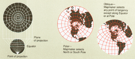
Projection Views
- polar view
- oblique view
- equatorial view
- planar polar
- conic oblique
- cylindrical equatorial
Projection Properties
- Equidistant
- scale equal in all directions
- distortions occur in area and direction, except at the tangent point
- examples: gnomonic, sinusoidal, conic, and polyconic
- Conformal
- preserves shapes of land masses
- meridians and parallels intersect at right angles
- size of most areas is distorted
- examples: Mercator, Stereographic Azimuthal, Lambert Conformal Conic
- Equal Area
- maintains area between parallels and meridians even if this means distorting other factors
- examples: Albers Equal Area Conic, Lambert Equal Area, Sinusoidal
- True Direction
- preserves angles at small-scales
- attempts to keep direction over entire map
- rhumb lines are lines of true direction on these maps
- examples: Mercator and Robinson
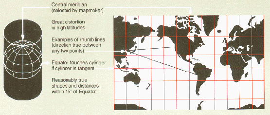
Projection Families: Cylindrical
- Mercator
- cylinder tangent at the Equator
- meridians perpendicular to parallels
- both meridians and parallels are represented as straight lines
- rhumb lines are lines of constant bearing
- large distortions in the high latitudes
- map is somewhat conformal
- Miller Cylindrical is somewhat similar
- Transverse Mercator
- cylinder tangent to central meridian
- no straight rhumb lines
- used frequently by the USGS for North-South extents
- conformal for shapes
- Oblique Mercator
- cylinder tangent to Great Circle other than Equator or Meridian
- good for navigation along Great Circle routes
- no rhumb lines

Projection Families: Planar
- Gnomonic
- plane tangent to one point on the globe
- all straight lines are Great Circles
- rapid distortion away from the tangent point
- good for navigation
- Orthographic
- projection point at infinity
- good perspective view of Earth
- used in media for global map projections
- example: Gall-Peters
- Stereographic
- used for mapping polar extents greater than 80° N or S
- any straight line through tangent point is a Great Circle
- used to solve spherical geometry problems
- examples: Azimuthal Equidistant and Lambert Equal Area


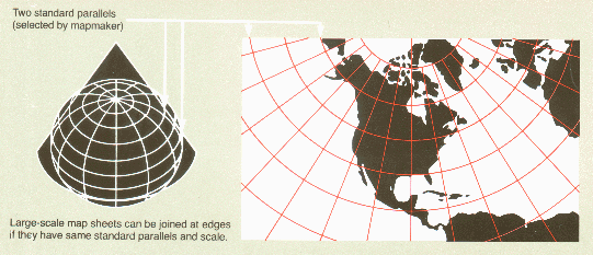
Projection Families: Conic
Notes:
- meridians appear as straight lines
- lines of latitude are parallel arcs
- standard parallels occur at tangent point
- very useful in depicting mid-latitude regions
- Lambert Conformal Conic
- uses secant points so that there are two standard parallels
- used by USGS for maps between 33° and 45° N
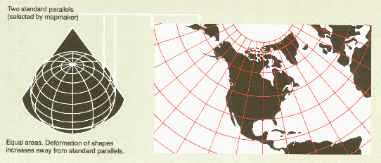
- Albers Equal Area Conic
- similar to Lambert Conformal Conic with standard parallels at 29.5° and 45.5° N
- excellent for areas of large east-west extents
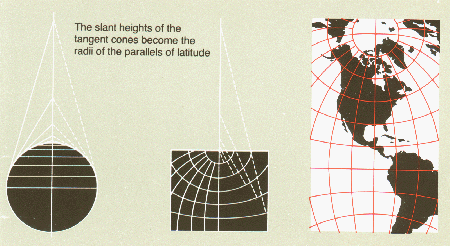
- Polyconic
- mosaic of strips of conic projections
- tangent points for each latitude
- good for north-south orientated features, but seldom used
- compromises shape, direction, distance, and area trying to minimize each distortion
Projection Families: Pseudocylindrical
Notes:
- created mathematically using different shaped cylinders
- these are the "funky-looking" projections!
- Robinson
- good balance between size and shape for all latitudes
- directions are true along parallels and central meridian
- distances are constant along Equator and other parallels
- adapted for National Geographic's world maps in 1988
- Goode's Interrupted Homolosine
- good for mapping north-south continents, like South America and Africa, if they are located on a central, tangent point
- combination of Sinusoidal and Mollweide Homolographic
- used in media for global map projections
- Sinusoidal
- graticule spacing retains property of equivalence of area
- proportional area maps
- accurate distances along central parallels and meridians
- distortion of shape away from meridians and near the poles
- first used in 1570 by Cossin and Hondius


Miscellaneous Terms
loxodromes:
- a.k.a. rhumb lines
- line of constant bearing
- all parallels and meridians
- special projections can produce other loxodromes, such as Mercator and Oblique Mercator (curved rhumb lines)
- shortest distance between two points on a globe
- useful to navigators
- special projections can produce Great Circle Arcs, such as Orthographic, Stereographic, Gnomonic, Lambert Azimuthal Equal Area and Azimuthal Equidistant